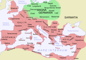
Stampa:Ptolemaeus Magna Germania.jpg

Daqs tad-dehra proviżorja: 800 × 575 pixels. Riżoluzzjonijiet oħra: 320 × 230 pixels | 640 × 460 pixels | 1,024 × 736 pixels | 1,280 × 920 pixels | 2,560 × 1,840 pixels | 5,440 × 3,909 pixels
Fajl oriġinali (5,440 × 3,909 pixel, dimensjoni: 27.13 MB, tip ta' MIME: image/jpeg)
Kronoloġija tal-fajl
Agħfas fuq il-grupp data/ħin biex tara l-fajl biex tara kif jidher dak il-ħin.
| Data/Ħin | Minjatura | Qisien | Utent | Kumment | |
|---|---|---|---|---|---|
| kurrenti | 21:20, 31 Ottubru 2009 |  | 5,440 × 3,909 (27.13 MB) | Mediatus | {{Information |Description={{de|1=EVROPA TABVLA QVARTA – Quarta Europe Tabula continet Germaniam cum insulis sibi adiacentibus. Die Karte zu ''Magna Germania'' aus der im Original griechisch verfaßten ''Geographike Hyphegesis'' des in Alexandria wirke |
Użu tal-fajl
Il-Paġna segwenti twassal għal din l-istampa:
L-użu globali tal-fajl
Il-wikis segwenti jużaw dan il-fajl:
- Użu fuq als.wikipedia.org
- Użu fuq ast.wikipedia.org
- Użu fuq bg.wikipedia.org
- Użu fuq br.wikipedia.org
- Użu fuq ca.wikipedia.org
- Użu fuq cs.wikipedia.org
- Użu fuq da.wikipedia.org
- Użu fuq da.wikibooks.org
- Użu fuq de.wikipedia.org
- Artaunon
- Kalisia
- Arae Flaviae
- Germania magna
- Oppidum auf dem Staffelberg
- Leuphana
- Benutzer:Drekamu/Notizen
- Amisia
- Portal Diskussion:Mecklenburg-Vorpommern/Archiv/1
- Treva
- Viadrus
- Benutzer:Mediatus/Bilder
- Gauonarion
- Sousoudata
- Tarodunum
- Wikipedia:WikiProjekt Germanen/Toponymie
- Bikourgion
- Alisus
- Kandounon
- Tropaia Drousou
- Luppia
- Mersouion
- Aregelia
- Loupfourdon
- Karrodounon
- Wikipedia:WikiProjekt Germanen/Projekt
- Segodounon
- Alcimoennis
- Wikipedia:WikiProjekt Germanen
- Rougion
- Siatoutanda
- Fabiranum
- Tekelia
- Lirimeris
- Marionis
- Marionis altera
- Kenennon
- Mounition
- Lakibourgion
- Aitouia
- Ouirition
Ara l-użu globali ta' dan il-fajl.


